**Facebook Post 091216 at 9:01AM**
Currently I’m in North Woodstock, NH, at a hostel called The Notch. It’s really nice and the woman who runs the place is a total sweetheart. It was a recommended stop by the people at White Mountain Hostel in Gorham, NH. Not a bad one, but it was a bit off the beaten path. Once I got to the trail head, I had to walk another 5-7 miles to get to the hostel. Which means today I will be walking back to that same trail head before ever even stepping foot on trail. All good though, I had no choice anyway. I’m out of food and had to resupply. For my next resupply, I mailed a box up to Glenncliff, NH. Supposedly it will be hard for me to find an actual resupply location there, so I mailed my groceries ahead. Since it was basically maybe a two day supply at best, I will need to find more food quickly after. It amazes me as the days roll by how much food I actually need to sustain myself. Not that this is something new, but the Whites are pretty brutal and require a lot of energy to finish, therefore as much food as I can fit into my mouth. In fact, I literally could stop every hour and eat.
Aside from all the food talk, the trail in The Whites has been up and down, literally. The climbs can be insane, and the the descents just as bad, if not worse. The fact that I have not broken my neck or slipped off a cliff amazes me. There’s still time though. (LOL) If I had known there would be so much scrambling and rock climbing, I may have passed on the whole endeavor. Dude, its downright dangerous in some places, and if you are not the athletic type, I would say stay out of the woods. Although I have made it to North Woodstock, the other hikers say there are still plenty of The Whites left to climb. I had made the assumption, by looking at the map, I may be through the worst of it, but apparently there is at least one more mountain region I need to go through, Mt. Moosilauke. From what I can tell from the few pages I have in front of me out of the AT Guide, it looks like The Whites may end somewhere in the low 400 miles of my trip. I’m at around 375 now. Looking good. They tell me you know you’ve finished The Whites when you come across trail magic from The Omlette Man. He sits about 2 miles north of route 25 and serves omlettes to all the hikers. Only catch, I have to get there before 5pm, when he starts packing it up. Will do.
Other than that, I have met a couple idiots out here. One worked for Pinkham Notch. I asked where the trail head was once I was passing through their lodge area, and he basically misinformed me on purpose that camping was forbidden anywhere between their location and the next designated camping spot, which was 4 miles away. It was 9pm, when I went through there. I was obviously alone and it was dark, and obviously had been hiking already the majority of the day. As far as I’m concerned, his intention was to harm me. He was a total dick. He made sure to bring me to a location where not only could I see the trail head, but so that there was a large audience. Then he started talking about how people like me shouldn’t be allowed to hike because we poop all over the trails, etc., etc., etc.. It was so offensive, one of the women standing nearby started speaking up, but he kept going on and on. Creeper!!!!! Yes, he is a Pinkham Notch employee. Lovely. And I assume its not the first time he has given that speech. BTW, he can go fuck himself, I stealth camped anyway. AND it’s not illegal, you just can’t do it within a certain distance of the lodge, not 4 miles. Dick. the other asshole was just some guy on the trail, who looked like a day hiker. When I didn’t feel like turning on my phone, because it was low on juice, I simply asked him the direction I should be heading. He told me, but I made a comment that I had just come from that direction and he started going off on me about how he has no reason to lie to me, and how he hopes I have better direction on the rest of the trail or I might find myself hopelessly lost, etc., etc.. Why people want to be dicks in such pristine of environments I have zero understanding. Boggles the mind. Luckily I just nod my head, and go about my business. No need to correct the idiots of the world. No time.
So, I’m still trucking along. Other than that, people in general have been great. I’m loving putting in the hard miles, except when its too hot, or too cold, but I’m guessing that’s part of the game. Left my shorts at White Mountain Hostel; Notch gave me new ones. Got my period early. Wasn’t supposed to get it at all. Have a huge bruise on my right thigh. Tangled with a tree limb coming down a mountain. AND my camera on my phone seems to be working again, although with a few glitches, but that’s pretty amazing. Thank you two weeks in a bag of rice. I constantly don’t have enough food, but I don’t want to carry 30 pounds of food with me everywhere. I still haven’t gotten in a car, but that will change once it’s time to get off trail for my grandma’s funeral. And yeah… That’s it.
11:25AM Start Day 27 (091217)
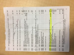
•11:25AM (Estimate) Ethan Pond Campsite (Mile 348.3)
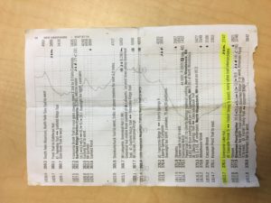
•6:30PM Trail west to summit of Zeacliff Ridge (Mile 356.2) sleep
• 4:45AM Wake up, pack
•5:45AM on trail
•11:25AM (Estimate) Garfield Pond
(Mile 363.6)
11:25AM End Of Day 27
APPROX 15.3 Miles